(This is one of a series of articles about National Nature Reserves commissioned by English Nature.)
Cow Green reservoir 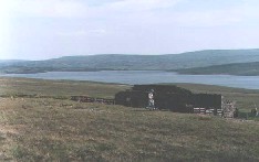
With a scattering of snow across the hills and waves on the reservoir whipped into spray by a cutting wind, the scene can be bleak indeed. Softened by the warm haziness of a day in late spring, the bleakness remains. Yet it has a compelling beauty that makes the visitor reluctant to forsake the soggy viewpoint.
Even the names have a hard-edged resonance that gives their repetition something of the character of a litany: Cow Green, Cauldron Snout, Falcon Clints, Cronkley Scar, Widdybank Fell. There is a music here that complements the scenery and orchestrates the call of curlew, lapwing, grouse and golden plover.
Covering an area greater than 7000 hectares, westward from High Force almost to the summit of Cross Fell, the National Nature Reserve of Moorhouse – Upper Teesdale is one of the largest in England. It is an amalgam of two former nature reserves and follows the course of the River Tees for its first twenty miles, encompassing an amazing range of scenery.
Trickling out of the sodden sponge of the highest Pennines, the water flows through heather and blanket bog, gathering supplies to fill the reservoir at Cow Green. It flows over the dam, churns brown, peaty pools into an off-white froth, and almost immediately crashes down the dolerite staircase of Cauldron Snout. It follows a craggy gorge, runs out into hay meadows for a leisurely meander, then falls over the abrupt shelf of High Force.
 Cauldron Snout
Cow Green reservoir was constructed during the late 1960s to provide water for the industries of Teesside. Its building created controversy, as its waters inundated 312 hectares of scientifically important habitats, containing rare plants found nowhere else in England.
To the west of the reservoir lies the Moorhouse section of the National Nature Reserve. English Nature owns the freehold to its 3894 hectares. Its southern boundary crawls up the side of Knock Fell then over the Pennine watershed. It moves north for a few miles to enclose Great Dun and Little Dun Fells, then returns over the saddle between the latter and Cross Fell to follow the infant Tees back down to Cow Green.
After the last ice age, much of the area was colonised by birch trees. As the climate grew warmer and wetter, these were replaced by the heather, grasses and mosses that decayed to form a blanket of peat, from one to four metres deep, that now covers the remains of the trees.
The land in and around the National Nature Reserve owes its appearance to the grazing of sheep during the last thousand years. English Nature manages the reserve so as to conserve the moorland habitats while monitoring any changes brought about by sheep farming and recreational use.
Part of the Pennine Way follows the high summits within the reserve, so that hundreds of walkers each year enjoy its spectacle. To the east, the moorland slopes are gentle. Channels cut through the peat to bedrock and carry tributaries into the Tees, which runs along the valley bottom. The western escarpment is much steeper and falls to the plains over which the Eden flows. Beyond that lies agricultural flatland reaching across to the hills of the Lake District.
English Nature also provides facilities for research. The geology and soil structures have been extensively studied, as have the interactions between species of plant and animal life. Weather observations have been made continuously since 1952, and the effects of heather burning on the grouse moors, grazing and climate change are documented in several hundred scientific papers. This means that the National Nature Reserve contains some of the best understood upland environments in the world.
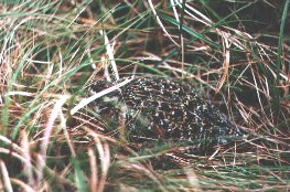 Grouse chick
Few mammals are found here, other than rabbits and the occasional fox. Birds, however, are more plentiful and include red and black grouse, snipe, curlew, lapwing, golden plover, dunlin, teal, mallard and widgeon.
Stretching away from the eastern end of Cow Green reservoir, the Upper Teesdale half of the National Nature Reserve offers a complete contrast. It is managed by a partnership consisting of English Nature, local farmers and the Raby and Strathmore estates.
Starting at the car park that overlooks the lake, a nature trail has been laid out by the staff of English Nature. This follows a well-surfaced track, much of it negotiable by wheelchair, for about one-and-a-half miles, along the base of Widdybank Fell. It leads the visitor past the spoil heaps of old lead and barytes mines and across a number of different geological zones, each with its own ecology.
The early rocks of Upper Teesdale consist mainly of carboniferous limestone, laid down by the corals of ancient seas. Nearly 300 million years ago, volcanic activity forced through these the quartz dolerite of the Great Whin Sill to form the crags that dominate the land beyond the dam. The heat and pressure of the vulcanism cooked the existing rocks into a crystalline marble known as sugar limestone.
Spring gentian 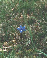
It is the varied habitats created by this geological history that give rise to the flowers for which Upper Teesdale is world famous. Often referred to as the “Teesdale assemblage”, these are Alpine and Arctic in nature, and have survived here since the last ice age. Mountain pansies are abundant, along with dog-violet, the starlike spring sandwort and common rock rose. The bogginess of the ground encourages several species of sphagnum moss and insectivorous plants such as butterwort and sundew. The pride of the National Nature Reserve, however, is the rare, deep blue spring gentian, found in the British Isles only in Teesdale and the west of Ireland.
From the end of the nature trail, the ground drops steeply to the top of Cauldron Snout. Here, the track becomes much more rugged as it threads its way, sometimes precariously down the side of the cataract. In strong winds, the spray falls like rain, drenching the slippery rocks, which need care for their descent.
By comparison, the flat approach from the bottom of Cauldron Snout to Falcon Clints is quiet. The Pennine Way, having come back over the hills from Dufton, is picked up again and follows boarded walkways and large, semi-submerged rock slabs over the boggy terrain of the riverbank.
Falcon Clints and the crags of Cronkley Scar, across the river, are part of the Whin Sill. As the Tees flows out of their gorge, it emerges into boggy pasture, which in spring, is a yellow blaze of buttercup and noisy with the constant call of curlew. Every walled field, large or small, contains numerous rabbits and nesting lapwings. Fiercely protective of their chicks, the latter will dive-bomb, without hesitation, any pheasant that comes too close.
Over the next couple of miles, the river swells in readiness for its final spectacular, which sees it crash, in full volume, over the precipice of High Force, said to be the largest waterfall in England.
After reaching such a crescendo, the Tees has little else to do but bid farewell to the National Nature Reserve and continue on its way towards Middlesborough and the North Sea.

Nice postt thanks for sharing
LikeLike