The Hurrungane from Turtagro 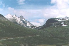
I tried to creep up on the Hurrungane from behind. That proved not to be a good idea. In terms of energy consumption a frontal assault would have been preferable. Nevertheless, my roundabout approach enabled me to view the mountains from several angles before I ventured into their midst.
The Norwegian Jotunheimen contains the highest mountains in Northern Europe. More than 250 peaks rise above 1800m. Here the remnants of the Ice Age linger and glaciers abound, carving steep-sided valleys into the bedrock and leaving narrow arêtes and sharp pinnacles to stand proud of the snow like mini-Matterhorns. The Hurrungane, the most rugged of the mountains, occupy a niche somewhere between the Alps and the Cuillins, though much closer to the former. With summits hovering just below 2400m, they cluster around the south-west corner of the Jotunheimen, a few miles beyond the eastern extremities of the Sognefiord.
It was the Cuillin-like nature which first suggested itself as I stepped off the coach at Turtagro. The Alpine aspect only became apparent as I neared the 2068m summit of Fannaraken. From there the Styggedal and Gjertvass glaciers looked dangerously unstable, while the ridges and pinnacles above stood blade sharp against a pure blue sky.
The view to the east extended over the whole of the Jotunheimen, with countless peaks, glaciers and snowcaps catching the sharp light of early evening. To the west the Jostedalsbreen, Europe’s largest ice sheet, glared with the gold of the dipping sun.
I spent the night in the spartan comfort of the Fannaraken hut. Standing on the rocky summit, perched above its own glacier, this is the highest hut in the Jotunheimen. It is owned by the Norwegian Mountain Touring Association (DNT), and provides excellent meals and a night’s sleep at very reasonable prices. No one who arrives at a DNT hut will be turned away, whether they be members or not.
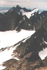
The following day began misty though this soon cleared. I moved south to a col, then up Kaisaren, the next peak, before dropping to the frozen Gjertvatnet lake. The Hurrungane glaciers looked even more formidable from this closer distance, certifying that the scenery was still in a state of flux and the grinding forces of the Ice Age had not yet completed their work. Another visitor to the Fannaraken hut told me that, after decades of retreat, the glaciers were now showing signs of advance, contrary to the general trends in global warming. Ironically, this is probably due to climate change, with the prevailing winds picking up more moisture from the warming seas, leading to greater precipitation over the glaciers.
Gjertvasstind from Kaisaren 
The track led downhill with the result that in an hour I dropped from winter chill to summer valley heat.
The hut at Skogadalsboen proved quite luxurious and very spacious, more like an up-market Youth Hostel than a mountain hut. After a comfortable night’s sleep I decided to head for the Skagastolsbu hut, set in the very heart of the Hurrungane. This decision led to one of the toughest days I have ever spent in a mountainous region, and I never left the valleys.
I followed a track down to the bank of a river, which crashed its way southward through the narrow gorge of Utladalen. The track was there all right, as were the bootprints of a recent traveller, which I followed all day. But it was the most tortuous track I have ever taken. It went up and down over cliffs, through dense vegetation and across a precarious bridge. It then continued with equal difficulty along the other bank.
At first I was in shade. Then I moved into the sun which became merciless. The thick shrubbery and near vertical walls of the gorge precluded the possibility of any cooling breeze. Only the abundance of water coming down the hillsides prevented my dehydration. After little more than three miles, which felt like ten, the track began to lead upwards, climbing very steeply for more than a thousand feet, finally rising above the stifling heat of the near jungle into the welcoming cool and openness of Midtmaradalen.
Here the gradient was negligible, but the valley was long, and by seven o’clock I had had enough. I had not met a single person all day. I prepared a comfortable bivouac beneath a huge boulder that lay on a moraine between the ends of two glaciers.
Here I began to encroach on the mountaineering history of the Hurrungane.
The smaller, higher glacier to the north, which grumbled and thundered every half hour throughout the night as it shed chunks onto the moraine, is called after William Cecil Slingsby, a man revered in these parts, whose photograph hangs almost everywhere, and whose name is brought up in conversation as soon as any visitor says he is from England.
In the 1870s, Slingsby began a series of assaults on the Hurrungane which the Norwegians claim as the birth of mountaineering in their country. His most notable climb was that of Store Skagastolstind, the highest peak in the region and third highest in Norway. This was accomplished, by way of the Slingsby glacier, in a single day.
Rising early from my bivouac I crossed what was left of the moraine, then kicked steps up a series of snowfields until, by 9 a.m., I had reached the Skagastolsbu hut.
This was a real hut, the smallest I have seen, completely basic and at the opposite extreme in the spectrum of comfort from Skogadalsboen. It stands on the col between Skagastolstind and Dyrhaugstind and is the main launch pad for the major rock climbs in the region.
I cooked myself a meal on the hut’s single functional butane stove, then, feeling refreshed, moved up in the direction of Store Skagastotstind.
 Above Skagastolsbu
Much of the ridge involved steep scrambling up boulder and slab, with the occasional snow patch. The gabbro was rough, but the hard crusty black lichen that covered it was rougher, and after several hundred feet the tips of my fingers were beginning to bleed. About 150m from the summit I decided to stop. The rock was getting steeper, I was alone and unroped and knew nothing of the routes to the top. I was, however, well higher than the surrounding peaks and could look across them to the next line of summits and the great North Wall of Ringstind, one of Norway’s last big unclimbed problems.
I slept the night in the hut, sharing the cramped accommodation with six climbers. In an emergency, perhaps a single other person could have been squeezed among us. The next day, I crossed the narrow snow bridge over the bergschrund and descended the Skagastols glacier and the three-hour walk to Turtagro.
After a few days on Galdhopiggen, Norway’s highest summit, and some of its satellite peaks, I returned to the Tutragro Hotel as a base for some final trips to the Hurrungane.
Dyrhaugstind looked an easy two-hour walk. It turned out to be a four-and-a-half-hour effort up tussocky shrub and vegetation, steep boulder slopes and several extensive snowfields. The rewards were more than adequate compensation.
I reached the summit ridge quite suddenly, and gazed over a cliff that fell some two-and-a-half thousand feet to the Skagastols glacier and its meltwater lake. Beyond, the walls of the far side of the valley rose impressively toward the summit of Store Skagastolstind. The high point of my previous visit was hidden in cloud, but from my position now I could see the mountains to the west, which had been partly eclipsed on that occasion by my present mountain.
The ridge narrowed as it rose until it became a small pinnacle. There I caught up with four others who turned out to be the first English people I had met in nearly two weeks in the Jotunheimen. We moved on together, scrambling, often precariously, over several more pinnacles to the highest point. The ridge continued farther, descending over a few more narrow humps and a distance of about half-a-mile before it plunged vertically to the col on which stood the Skagastolsbu hut.
 On Dyrhaugstind Summit
The following day, cloud hung low over the mountains. More in hope than anticipation I set off for Nordre Skagastolstind. The terrain was similar to that on Dyrhaugstind, but with much less snow. 1994, I was told, had been a lemming year, and several small, sandy-brown carcasses lay at intervals on the lower slopes, as witness to the swarming phenomenon of these strange little rodents.
I rose into the cloud, through which a vague sun tried to break. For a time I was cocooned in a mist-free space surrounded by a pale grey wall. Then the gloom thickened and only a final rock scramble to the summit gave something of interest. A ridge similar to that on Dyrhaugstind began from here, but I could see none of it. Nor could I see the view down to the Styggedals glacier and across to Fannaraken, and reverse of that which had first stimulated my interest in the Hurrungane. My English companions of the previous day had assured me that the view was worth the struggle. I would have to be satisfied with that, along with the purely personal satisfaction of having climbed another 2100m peak.
That evening, I stood on the balcony of the Turtagro Hotel as the cloud lifted and a sharp sunlight bathed the mountains. My visit had allowed me little more than cursory inspection of the region and a tantalising glimpse of its possibilities. Despite my short acquaintance with them, these hills were beginning to feet like old friends and I perhaps sensed a little of what had drawn Slingsby back to Norway year after year.
There is little possibility that I shall ever emulate Slingsby, but at least I have made a start.
