I brushed the thin layer of snow from the base of the trig point and sat down. Despite the low ambient temperature, there was no breeze whatsoever, and the sun, shining through veils of cloud, felt warm on my face. A few metres from the trig point, a tall cairn crowned a much larger rock pile and interrupted the flow of the dry stone wall that followed the crest of the summit ridge.
At 656 metres, Grey Nag is the fourth highest peak in Northumberland. Only the Cheviot and Hedgehope Hill, far to the north, and Killhope Law, which straddles the Durham border a few miles to the east are higher. Rising above the South Tyne valley, it occupies a south-western bulge of the county, which encroaches into Cumbria. The border traced a crooked arc about a mile from where I sat. As I gazed around, while eating my lunch, I realised that this must be one of the great unsung viewpoints in the whole of Northumberland.
I had left Slaggyford two hours earlier, stepping out of the car into a crisp, clear morning. The ice on the pond beside the caravan park was thick enough to stop a stone. The hedgerow held an abundance of berries, and the frozen roadside mud was scattered with fallen leaves and acorns. There would be plenty of food during the cold months for the red squirrel I had seen here a few weeks earlier, scampering along the top bar of a fence.
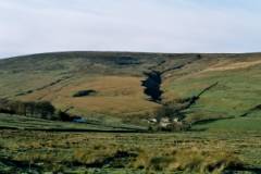
I took the road uphill out of the village for ten minutes, then followed the rubble track that led south. The gradient was gentle for a mile, and levelled out as the track contoured along the side of Thornhope Fell. The winter sun hung low, dazzling me as I walked toward it. Its slanting light picked out in sharp detail the scattered farm buildings, the sheep, the walls that sectioned the slopes and the river gullies that cut the hillsides to the west. Those hillsides were a patchwork of dark brown heather, red-brown bracken and the beige of grass and soft rush, with here and there the dark green of small conifer plantations.
A few hillocks to the side of the track were probably relics of the mining industry that once dominated much of the North Pennines. I passed a more recent excavation, which I assumed to have provided the rubble for the track I now walked on. Across the valley, an isolated limekiln stood beside the overgrown hollow of a long-abandoned quarry.
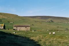
In places, thick patches of water ice that had leaked out of hillside springs crossed the track. Frost remained clinging to the grass. I did not hurry, so it was a little over an hour after leaving Slaggyford when I reached the end of the track, and a wooden hut that appeared to be a refuge for grouse shooters.
As I followed the wall up the open hillside, five grouse ran ahead of me. The sky remained blue, but a thin haze drifted over the sun and the temperature fell noticeably. On another day, the slopes would have been swampy. Now, the sphagnum was frozen and the turf crusty hard. Grassy strips had been removed in places and laid along the top of the wall, probably for shooters to lean on while waiting for the grouse to fly into range.
At the crest of the ridge, the wall turned right and led at an easier angle to the summit. As I approached the cairn, the view began to suggest its potential, but only revealed itself fully when I stood on the top.
Grey Nag Summit 
To the north lay the Tyne valley, Kielder forest and the Cheviot. Swinging east were the Simonside hills in the distance and the nearby plateau of Whitfield Moor. Just south of east, the horizon was marked by Killhope Law, and farther south, Cross Fell and Great Dun Fell, the highest points on the Pennine chain.
To the south and west, the land fell away into the broad vale of the Eden, before rising again to the Lake District hills: High Street and Helvellyn, separated by the deep Ullswater gap, Blencathra, Skiddaw. The view was wonderful, and the air so clear as to extend it across the Solway to the hills of Dumfries and Galloway, the Chapel Cross cooling towers and the moorlands of the Cumbria-Scottish border.
This was the kind of view that holds one’s attention, and I continued gazing at it for several minutes before reminding myself that I should sit down for lunch.
After a total of about forty-five minutes, and with some reluctance, I left the summit to return to the South Tyne valley. The sun was now behind me, and as I descended into the late afternoon shadow, I felt the first frigid breath of a light breeze. The distant Cheviots were still bathed in sunshine and sharply etched against the sky.
Rather than follow the crest of the ridge, over Black Hill and Great Heaplaw, I picked up the parallel lines left by a vehicle of some kind. These ran across the northerly slopes and down to a more prominent track, which itself led to the valley and a mile walk along the road back to the car.
The secretive air and sense of isolation of Grey Nag are heightened by the fact that its slopes, on the South Tyne side, are covered by dry stone walls without obvious gateways, which discourage a more direct ascent. Nevertheless, my back door approach had worked. Even with my frequent and sometimes lengthy stops the whole walk had taken me less than four hours, ideal for a short winter’s day. And the quality of the view was out of all proportion to the effort I had made to attain it. It had been a surprising and altogether very satisfying day.
OWG Chairman, Jon Sparks (left) presents the Award for Excellence in the Single Feature category (October 2006). Holiday Inn, Edinburgh. (Photo: Jon Sparks)
