 Kosciuszko summit
Every corner has a name. Every name tells a story. Smiggin Holes, Blue Cow Mountain, Perisher Valley, Sawpit Creek, Widow’s Creek, Dead Horse Gap. The list goes on. Wild West names, redolent of Klondike days or cattle drives. There must be a hundred stories of courage, hardship or desperation hiding among the eucalypts between Jindabyne and Charlotte Pass.
The Wild West image had been seeded in our minds on our entry to Cooma the previous evening. Still jet-lagged after nearly a week from our flight to Sydney, we had driven 300 kilometres to this southern corner of New South Wales and felt we could not safely go farther. The broad thoroughfare was almost deserted. 1950’s photographs in a shop window could have been stills from an old John Wayne movie. We would not have been surprised to see clumps of tumbleweed rolling along the street.
This being March and the end of the summer sleep, we probably did not see Cooma in its true light. That would shine later in the year when the town would wake up to the first white flakes of winter and the skiers would pass through on their way to the mountains that would begin to merit their name.
The Snowy Mountains are Australia’s closest approach to an Alpine region., and then only for a few weeks from July to early September. Skiing was introduced here in the 1860s, and despite the unreliability of snow, the town of Kiandra, a few miles north of Cooma, claims to be the first in the world to have held competitive ski races.
During the 25 years following 1949, Cooma was the base for the construction of the Snowy Mountain hydro-electric scheme. Great dams were built across valleys and huge tunnels dug to link the newly created lakes. The machinery for power generation was installed. Many of the workers were refugees, displaced by Europe’s chaos after the Second World War. The avenue of flags in Cooma commemorates the men of 28 nations who were involved in this great engineering project.
Refreshed by a night’s rest, we drove the remaining 40 kilometres to Jindabyne. There, I left Therese and Brendan to relax for the day by the lake, and seek our accommodation for the next few nights. I continued up the road to Charlotte Pass.
Jindabyne, standing by its lake, is the main centre for winter sports in the Snowy Mountains. In June, its population of 4000 would swell to 30 000. The hotel manager later told me that he often had up to 1400 in the bar on an evening during a good season.
The road led past a toll booth that marked the entry to the Kosciuszko National Park, then on to a gentle uphill gradient through thick eucalypt forests. I passed a dead wallaby that had jumped into the path of a car, and farther on, a dead wombat. Elsewhere, a dingo skulked suspiciously along the roadside.
Jindabyne, though quiet, had a sprinkling of summer tourists to give it life. In contrast, the few villages I drove through were ghost towns, their hotels and supermarkets locked up and cable cars stilled. I seemed to have the road to myself.
It was around midday when I reached Charlotte Pass, which stood at a height of 1780 metres. Two Scottish visitors were just getting into their car. They had climbed Kosciuszko after a dawn start, but were disappointed that the summit had been covered in cloud and blown by a strong wind.
Nevertheless, I was here, and would probably never be again, and this was Australia’s highest mountain. I waved them goodbye and set off on the broad summit track.
Seaman’s Hut and Kosciuszko summit. 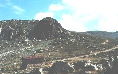
I usually prefer to get onto the hills early in the day. This day, however, benefited from my late start.
The track passed through the upper reaches of the snow gum forest for a few hundred metres. Cloud rested on the distant tops, but as I approached them, it thinned and began to rise. The gradient was gentle.
After about three kilometres, I came to a bridge over a stream. A plaque on a nearby boulder informed me that this trickle was the Snowy River, the source of which was only a similar distance away. The plaque also referred to peculiar, rock-climbing fish, mountain galaxias, that swam there. I did see some small fish, but none seemed willing to crawl out onto the boulders.
A little higher, I arrived at Seaman’s Hut. This stone refuge was built with the aid of a donation by the parents of a Laurie Seaman of New York, who with his companion, Evan Hayes, died here in a blizzard in August 1928. Inside the hut was a memorial to the four victims of a more recent tragedy, snowboarders who had died in similar circumstances, not far from here, in August 1999.
The track led round a bend beneath a small crag and levelled out at Rawson Pass. The summit trig point was now in sight. The clouds that had threatened earlier were now gone. After a further spiralling kilometre, I reached the highest point on the continent in brilliant sunshine.
It seems incongruous that such a large land mass as Australia should rise to no more than 2228 metres above sea level. The American couple who joined me on the summit told me that their home in Wyoming stood at a greater altitude.
They had set off earlier than I from Charlotte Pass, and had come by way of the longer route, north to Blue Lake and Carruthers Peak, then south-west to Kosciuszko. I felt that theirs was probably a more interesting route than mine, and certainly more demanding. I made the mental suggestion that I might try at least part of it the next day.
The Snowy Mountains are neither particularly rugged nor precipitous. They are, however, very isolated. Their lower slopes are covered by near impenetrable forests, and were it not for the winter sports infrastructure, would be very difficult to access. They form the southernmost end of the Great Dividing Range, which snakes for more than 2000 kilometres down the eastern side of Australia, and presented a formidable barrier to the early European settlers.
To the north of Kosciuszko are numerous peaks and large wilderness areas that would repay a visit by those prepared to undertake the many long, high-level treks they have to offer.
I returned to find that we were booked into a 3-bed room at the Jindabyne Lake Hotel. Other rooms had up to six beds, so larger parties could be accommodated. The hotel was inexpensive, and situated to give a beautiful view over the lake. In winter, the cost would be much higher. A flock of red and green parrots squawked in a tree just below the picture window that filled the lakeside wall of our room.
The next morning looked as though it might bring rain, so we decided to head for Thredbo, along a valley parallel to the one I had driven up the previous day.
Bushwalking above Tredbo 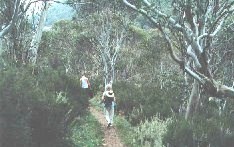
Thredbo is a small but thriving town, and unlike those leading to Charlotte Pass, was open for summer business. Its houses climbed up the wooded slopes to give it an Alpine appearance, and many of its cable cars were running. From the highest point reached by one ski lift, a track leads to Rawson Pass and so to Kosciuszko. The more energetic could reach the same point by way of Dead Horse Gap, farther up the valley.
The threatened rain began to fall, but remained showery rather than persistent, and its effects were mitigated by the heat of the day.
Bushwalking is one of the many attractions around Thredbo. Walks can be as long or as short as one wishes. We followed a track for two or three hours, first along the river bank, then up and across the hillside through the dense forest of eucalypts. Wildlife was abundant. A great variety of birds flew around us, sporting colours more more varied and vivid than those seen in Britain. Some of the biggest beetles and winged insects I have ever seen crawled across the track. The air was filled with the constant chirp of crickets.
We saw several spiders, one of them with a brilliant red patch on its back. As many of these are poisonous, even lethally so, we treated them with some caution.
While I was photographing some creepy-crawlies, Brendan and Therese called to me in a whisper. When I joined them, they pointed into the undergrowth at the side of the track. A dark brown snake, about a metre long, with bright yellow markings along its sides, wound its way slowly through the fallen leaves. It was unperturbed by our proximity, and we watched its unhurried progress until it disappeared into the thicker vegetation of the forest floor.
The following morning, we left Jindabyne. Cloud hung low over the mountains and mist thickened above the trees. We stopped at the dam and looked back across the lake. A rainbow hung over the fast disappearing slopes. I wondered, briefly, if the adage about shepherd’s warnings applied in Australia.
