Though the ferry crossing from the Queensland coast takes barely ten minutes, once you land, you know you are in remote territory. People have disappeared here, and accidents often lead to rescues on an epic scale. This is strictly 4WD country. An ordinary car would not get five yards. For this is Fraser Island, the world’s largest island composed entirely of sand.
We set off from Brisbane shortly after 8 a.m. Our journey took us past the precipitous, spiky Glasshouse Mountains, through miles of eucalypt and pine forests and the cane plantations that provide Australia with 95% of its sugar. Four hours after leaving the city, we arrived at Inskip Point, just north of Rainbow Beach, and transferred to our 4WD vehicle.
On leaving the ferry, we drove a short distance along a deeply rutted track that threw us about without mercy. Sea eagles circled over the trees and dingoes mooched around in the scrub vegetation, scavenging for scraps that might be tossed away by travellers. We then broke through a short section of soft sand into which we sank up to the axles, before emerging onto the seashore. We were now on the Great Sandy Highway: 75 miles of beach, that runs up the eastern side of Fraser, and serves not only as the main thoroughfare but also as the island’s only airstrip.
Great Sandy Highway 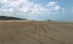
The sand of which Fraser Island is composed is rich in oxides of titanium and zirconium, and originates in the Blue Mountains, west of Sydney. It is washed by rivers into the sea, then carried northward by ocean currents, to be deposited here, rising in some places to a height of 200 metres. The western coast is more than
700 000 years old, while that on the east is less than 500. From east to west, a distance of less than ten miles, the island displays several distinct ecologies, demonstrating how the land has evolved through time.
The eastern strip shows young vegetation and newly formed humus. Farther inland, where the humus has had time to build up, stand tall, dense rain forest trees. Travelling west, where the soil has become old and depleted, one passes into a region of scrub and sand held together by 300 000-year-old roots. And finally are the mangrove swamps and rich marine life of the west coast.
Fraser Island is named after Eliza Fraser, the wife of the captain of a ship that was wrecked near here in the 1830’s. The survivors managed to make their way to the island and held out, with help from the aboriginal population, until their rescue, some months later. Eliza Fraser’s story was the inspiration for the novel, ‘A Fringe of Leaves’, by Australian Nobel Prize winner, Patrick White.
We drove for about 20 miles up the coast, sometimes splashing into the edge of the sea, but slowing down only to cross the many creeks that ran out of the scrub. At Eurong, we stopped for a short break.
This tiny village has chalets and camping facilities as well as a few amenities like shops and a garage. A visitor centre supplies information about the walking and vehicle routes. There is also a swimming pool at the hotel. Neither here nor on our drive up the coast did we see anybody in the sea. This was because of the threat posed by sharks and poisonous jellyfish that abound in the inshore waters.
I strolled out onto the beach, but retreated rapidly when I turned to see two light aircraft taxiing toward me at an alarming speed along the sand.
We now moved inland, the smooth progress of our coastal run replaced by the staccato bumpiness of soft sand and tree root. On either side of the track, at frequent intervals, lay shell middens left by centuries of aboriginal occupation.
Around us grew the darkness of the rain forest: tall eucalypts and trees with exotic names like tallow wood, brush box, black butt, Queensland kauri. And giving impenetrable ground cover and a look of the prehistoric, was a dense underlayer of cycads. The trees themselves hosted huge outgrowths of staghorn ferns and basket ferns: epiphytes that, unlike parasites, took no sustenance from the trees themselves, but merely hitched a ride on their branches, feeding on the water that trickled down the trunks and the discarded leaves that fell from the high canopy.
Rain forest epiphytes 
Much timber was cut down on Fraser Island from the 1860’s to 1991. The main tree to be harvested was satinay, a species almost unique to the island. Its value lay in its resistance to a marine creature that bores into wood. Because of this resistance, satinay was used to line the Suez Canal during its construction.
We stopped at Central Forest Station for a more leisurely look at the vegetation, but our visit was cut short when the rain forest began to live up to its nature. Within seconds, we were soaked, though the heat prevented any discomfort.
In the continuing rain, we drove to Lake Mackenzie, one of around 40 freshwater lakes that are dotted over the island. Some of these are called window lakes, and are part of the water table, drawing supplies from underground reservoirs. Mackenzie, on the other hand, is an example of a perched lake. It has no rivers leading into or out of it, but is fed by rain and loses its water only by evaporation. The water is held in the lake by a watertight bed of sand and compacted humus.
The ecology of Fraser’s perched lakes does not rid itself of pollution, and traces of radioactive fallout from the British nuclear bomb tests of the 1950’s can still be detected in the sediments. This said, however, the radioactivity is only marginally above background level, and there is no additional source of pollution other than the natural decay of the forest vegetation.
We stopped at a small clearing, and despite the rain, ran along a short track to the lakeside. As the jungle opened out abruptly, it revealed a scene that was as magical as it was unexpected. The shore was of white sand, and was backed by the forest. It had the appearance of a picture advertising a South Sea paradise. This was, of course a South Sea island, but we were in the centre of it, not on its coast.
About two dozen swimmers bathed in the clear, green water. And as if activated by a switch, the rain ceased, and a minute later, a hazy sun came out.
Lake Mackenzie 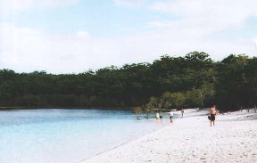
The sand was damp, but easily covered by a towel, for now that we were here, we had to sample the waters. It was like a swimming pool, warmer in fact, without any of the shivering hesitation that visitors from the British Isles expect as the norm. The lake was totally transparent. Its gently sloping floor leading to deeper water, and the lack of any currents meant that it was completely safe, and could be enjoyed by swimmers of any level of skill or none.
By late afternoon, we were on our way back to Eurong and the Great Sandy Highway. Frazer Island is not quite in the tropics, but is sufficiently close for its dusks to fall rapidly and early. By the time we reached the ferry, it was almost dark.
A single day is not enough to give more than a cursory appreciation of Fraser Island. One really needs to stay for a few days, much of it in the same place, so that some time could be given to encountering the richness of its fauna, which matches that of its vegetation. As well as dingoes and eagles there are brumbies (feral horses), frilled lizards, tortoises, goannas. And from high points above the shore, turtles, manta rays, sharks, dolphins and even humpback whales can be seen.
But such is the magic of this unique place that no visit would be long enough. A few days after leaving, one would want to start planning a return visit.
